


POLK, Monroe County, Indiana
About
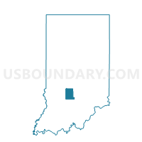
Outline

Summary
| Unique Area Identifier | 579801 |
| Name | POLK |
| County | Monroe County |
| State | Indiana |
| Area (square miles) | 38.79 |
| Land Area (square miles) | 34.16 |
| Water Area (square miles) | 4.63 |
| % of Land Area | 88.08 |
| % of Water Area | 11.92 |
| Latitude of the Internal Point | 39.04081020 |
| Longtitude of the Internal Point | -86.37360370 |
Maps


Graphs
Select a template below for downloading or customizing gragh for POLK, Monroe County, Indiana


Neighbors
Neighoring Voting District (by Name) Neighboring Voting District on the Map
- CLEAR CREEK 02, Monroe County, IN
- MARSHALL 02, Lawrence County, IN
- PLEASANT RUN, Lawrence County, IN
- SALT CREEK, Jackson County, IN
- SALT CREEK, Monroe County, IN
- WASHINGTON 4, Brown County, IN
Top 10 Neighboring County Subdivision (by Population) Neighboring County Subdivision on the Map
- Clear Creek township, Monroe County, IN (5,000)
- Washington township, Brown County, IN (4,896)
- Marshall township, Lawrence County, IN (4,660)
- Pleasant Run township, Lawrence County, IN (1,883)
- Salt Creek township, Monroe County, IN (1,513)
- Polk township, Monroe County, IN (360)
- Salt Creek township, Jackson County, IN (344)
Top 10 Neighboring Unified School District (by Population) Neighboring Unified School District on the Map
- Monroe County Community School Corporation, IN (120,715)
- North Lawrence Community Schools, IN (34,125)
- Brown County County School Corporation, IN (15,242)
- Brownstown Central Community School Corporation, IN (10,375)
Top 10 Neighboring State Legislative District Lower Chamber (by Population) Neighboring State Legislative District Lower Chamber on the Map
Top 10 Neighboring State Legislative District Upper Chamber (by Population) Neighboring State Legislative District Upper Chamber on the Map
Top 10 Neighboring 111th Congressional District (by Population) Neighboring 111th Congressional District on the Map
Top 10 Neighboring Census Tract (by Population) Neighboring Census Tract on the Map
- Census Tract 9680, Jackson County, IN (5,344)
- Census Tract 14.02, Monroe County, IN (5,216)
- Census Tract 9505, Lawrence County, IN (4,924)
- Census Tract 9749, Brown County, IN (4,815)
- Census Tract 9504, Lawrence County, IN (3,787)
- Census Tract 15.02, Monroe County, IN (2,724)